Dorset day three, 17 Oct 2010
Day three Itinerary
|
10:00 – 12:00 |
Walk to Old Harry Rocks from Studland car park |
|
13:00 – 15:00 |
Walk around Lulworth Cove to Fossil Forest and back to Stair Hole |
In-depth information from the rest of the web
For the geology of Lulworth Cove, click here
For the geology of the fossil forest, click here
Write up of day three by Elizabeth Staley
The Isle of Purbeck , although not an island, is a very distinctive and interesting area of upper Jurassic and Cretaceous rocks. We appreciated this as we approached it in the coach from the north across the flat heathland of the Wareham Basin. In front of us was a long chalk ridge, broken only by the impressive ruins of Corfe Castle. We turned east, still on the north side of this ridge.
We gained some height and stopped to look at the view across the lower land to the north and Poole Harbour. Below us was the well-hidden Wytch Farm oil field, the largest onshore field in western Europe. From Studland village we walked down to the shore and along to Redend Point, formed of soft red and yellow Eocene sandstone. The corresponding beds on the Isle of Wight provide the well-known coloured sands of Alum Bay. Alan pointed out some striking Liesegang rings, resulting from the movement of iron-rich groundwater.
We walked eastward along the rising chalk towards The Foreland. Alan showed us the vertical white cliffs, corroded at the base by flint pebbles which make up the narrow beach. A mile of grassland walking brought us to the point and Old Harry rocks. The sunny views were staggering : across Poole Bay to Bournemouth and beyond to Christchurch; to the Isle of Wight which, only a few thousand years ago, was joined to the chalk ridge where we stood; and at our feet to the chalk stacks, stumps and arches culminating in Old Harry, and more gleaming cliffs.
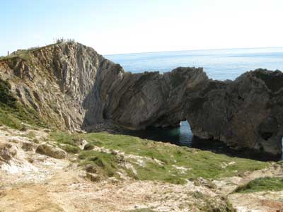
Back in the coach, we headed west, and then south up the chalk dry valleys and over the Down to Lulworth. After a quick lunch, we climbed along the steep narrow ridge dividing Stair Hole and Lulworth Cove. Alan explained the sequence of beds, structures and history of these two famous features. At Stair Hole the sea has broken through the outer barrier of Portland limestone, so that now the waves enter through a narrow gap and two arches. Behind, the Hole widens out due to the erosion of the thin, less resistant Purbeck beds of limestone and clay. This has revealed dramatic folding, from the Alpine orogeny. At the west end the beds are vertical and even overturned. At the east end is the double fold of the famous Lulworth Crumple.
From a point further up the same ridge we could see the view of the coast and the now familiar landmarks such as the Isle of Portland. We looked down into Lulworth Cove, and could see how its history is comparable with that of Stair Hole but has progressed further. The mouth of the cove, maybe originally cut by the stream from the north, is 200 or 300 metres wide. The soft Wealdon beds behind the Portland and Purbeck have been eroded, and now the chalk and the Greensand form the cliffs at the back, delineating the beautiful horseshoe shape of the cove. These beds are part of the northern limb of the Purbeck monocline, as shown by the steep dips to the north. From the beach of the cove, Alan pointed out more features. He extracted a piece of lignite (brown coal) from the Wealdon beds; explained how the refraction of the waves coming through the mouth helps to shape the round cove; and pointed out the Greensand beds, containing bivalves and trace fossils.
Most of us walked round below the cliffs and climbed up onto the Army range area east of the cove. Then we descended 90 steps to the Fossil Forest - an amazing array of apparent tree stumps and trunks on a cliff ledge. No fossilized wood remains (perhaps eroded out by the sea or taken by Victorian collectors!). What is visible is a trace image formed in the late Jurassic when a forest of trees like cypress and monkey puzzle was flooded. Thick mats of algae grew over the stumps to form burrs, which in turn became fossilized. Behind the same ledge are intermittent piles of collapsed strata which have been recemented together in haphazard shapes. They represent a complex story of chemistry and tectonic activity.
We met back in the village, where some had visited the useful Heritage Centre, and headed home to Weymouth. Those with appetite for yet more geology went with Jim on a brief tour of Weymouth’s building stones and monuments. We saw specimens ranging from local Portland stone to Norwegian Larvikite and Carrara Marble. Finding rocks in the streets round our hotel made a satisfying end to a sun-lit and sparkling day.
Pictures from day three
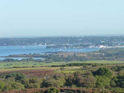
View of the Isle of Purbeck.
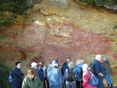
The group looking at the Liesegang rings, Redend Point,
Studland.
These were in Tertiary sandstone,
very poorly cemented.
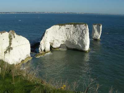
Old Harry rocks.
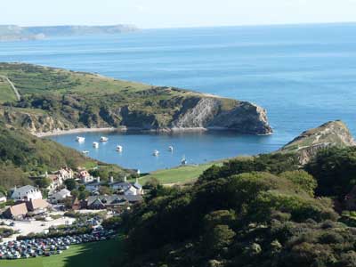
Lulworth Cove.
A classic example of marine erosion of rocks of uneven resistance.
Stair Hole and the Lulworth Crumple.
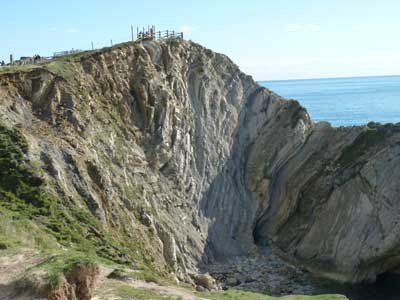
The Lulworth Crumple.
Dramatic folding,
from the Alpine orogeny.
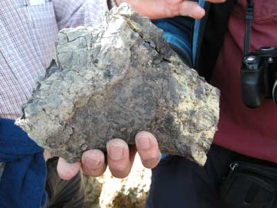
Fossil Wood (lignite) preserved in clay from Wealden
beds.
Found on the shore of Lulworth Cove.
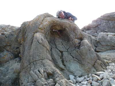
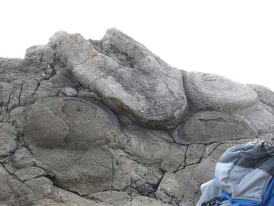
The Fossil Forest, with Alan for scale.
Stromatolite limestone mound, Fossil Forest.